
BRITS are braced for more bone-chilling temperatures with snow and ice set to batter parts of the nation today.
The Met Office have issued yellow weather warnings as temperatures plummet once more after a week of blizzard chaos.
Snow and blizzards hit Yorkshire last week
The white stuff covers cars and a small street in Cleckheaton, West Yorkshire
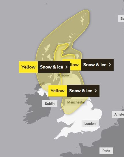 Three weather warnings have been issued by the Met Office
 Rain, sleet and snow followed by ice could spark travel chaos
The forecaster has issued a total of three severe weather warnings across the country, with as much as 10cm of the white stuff expected in parts.
The cold snap will will affect all of Scotland, parts of Wales and extends as far south in England as Birmingham.
A portion of Northern Ireland will also be impacted.
The first weather warning runs from 5am today until tomorrow morning.
Parts of the UK are currently being battered by gales with gusts of 50mph expected in Penzance and London.
And the Met Office warns that a combination of rain, sleet and snow followed by ice could spark transport chaos.
Commuters have been warned of treacherous journeys with an increased risk of injuries from falls on icy surfaces.
On Monday morning, northern areas can see the mercury dip to 3C which may gradually go down to 0C.
The UK Health Security Agency (UKHSA) issued a new weather alert on Sunday, warning that the freezing conditions “could increase the health risks to vulnerable patients and disrupt the delivery of services”.
The snowfall will drift south to cover the Midlands on Tuesday and Wednesday.
At the same time southern England will shiver in strong winds and freezing rain, with highs of just 4C to 7C expected.
The Met Office added: “A band of rain will gradually turn to snow from the north during Monday morning, initially above 200m, but later, to low-levels. 2-4 cm are possible above 200m and 5-10 cm above 300m.
“A few cms may develop locally at lower levels into the evening. Rain and snow should clear to the south of the area Monday evening, and with skies clearing, icy stretches will be possible on untreated surfaces.
“Occasional snow showers will follow into the north and west of Scotland during Monday evening and night giving a few cm of snow in places.”
It comes after a week of disruption caused by snow storm conditions across the country.
Heavy snowfall on Thursday night left drivers stranded for more than seven hours on the M62 in Greater Manchester and Yorkshire.


