
HOT and humid conditions are set to last for another two weeks with the mercury expected to reach a balmy 20C.
Brits are being treated to unseasonably warm weather conditions – but a jet stream will soon bring heavy rain and 50mph winds because of low pressure.
Temperatures are set to remain warm this week
But heavy rain and 50mph winds are on the way
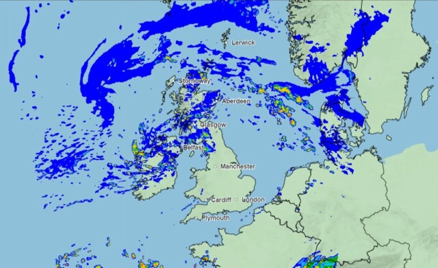 A jet stream is bringing low pressure to the UK
Speaking in the Met Office 10 Day Trend, Presenter and Meteorologist Alex Deakin said: “Low-pressure is going to dominate things for the next ten days, bringing spells of wet and windy weather and also some quite high temperatures.
It’s this low pressure that’s helping to draw warmer air up from the south, even though unsettled weather will be possible through the weekend and into early next week.
He added: “Because of that warmer air for the next several days, it’s going to be warmer than average by day and particularly warmer than average across the south at night.
“Between these weather fronts, there will, at times, be spells of sunshine and when the sun is out it’s going to feel quite mild.”
And forecasters predict temperatures could soar as high as 20C in the coming days – four degrees warmer than the average for this time of year.
October’s highest temperature ever recorded in the UK was 29.4C in the small market town of March, Cambridgeshire, on the first day of the month in 1985.
Forecasters have been hailing the warm weather as an “Indian Summer”.
It means a period of unseasonably warm, dry and calm weather which can make for an Autumnal heatwave.
It is usually followed by a period of colder weather or frost in the late Autumn.
Today the mercury will reach a maximum of 19C and it will be mainly cloudy with grey skies and showers, heavy during the afternoon.


