
BRITS are braced for the recent cold snap to continue, with a whopping 8in of snow predicted as temperatures plunge to -7C.
Heavy snow and icy roads have caused travel chaos and school closures this week, and more is on the way as arctic air blasts the UK into a deep freeze.
An icy blast has plunged the country in a deep freeze in the past week| Manchester
Dubbed the ‘Troll of Trondheim’ arctic winds have swept across the UK| Richmond Park, London
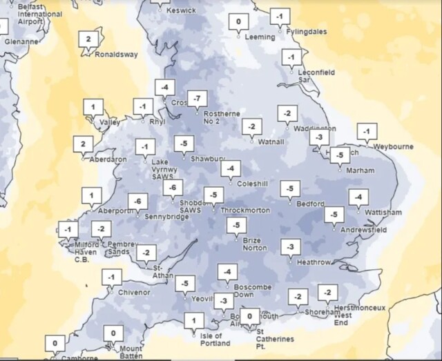 Temperatures fell as low as -7C today
The mercury fell to -7C this morning in Rostherne near Manchester, while Cardiff saw -5C and London -3C.
An icy blast has swept across much of the UK in recent days as freezing wind from the Arctic has reached us via Norway.
Dubbed the ‘Troll of Trondheim’, the wave of sub-zero air has sent the nation into one of its coldest winters in recent years.
Temperatures as low as -15C have been recorded in the past few days, while Scotland is set to see up to 8in of snow in the coming days.
The Met Office have issued yellow weather warnings in various parts of the country.
Today, warnings are in place for snow and ice on the east coast, from Northern Scotland to Newcastle, while a warning for ice stretches down the rest of the coastline to East Anglia.
A yellow warning for ice also covers Northern Ireland.
The Met is warning of severe delays to travel and the risk of injury from slipping on ice.
A further snow and ice warning covers most of Scotland throughout tomorrow, with more delays possible.
Pictures from around the country show lakes, ponds, canals and even Trafalgar Square’s famous fountain frozen over.
However, forecasters expect the extreme cold to ease later in the week and say milder temperatures are on the way.
The clash between the current freeze and the warmer air is set to bring snow, followed by heavy rain across the weekend.
The Met’s forecast going into next week said that Saturday will remain cold, but Sunday will become “much milder and very windy with heavy rain, preceded by snow in many areas.”
Further rain is also expected on Monday.
Meanwhile, the long-range forecast for December 19 to December 28 predicts a period of unsettled and “changeable” weather, with outbreaks of rain accompanied by wintry spells.
However, they predict that temperatures will be “close to normal in the south, and rather cold in the north.”
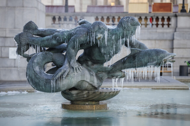
Even Trafalgar Square’s famous fountain froze over| Trafalgar Square, London

Heavy snowfall is expected in parts of the country in the coming days| Ugthorpe, North Yorkshire

Brits have been warned about ice on the roads and travel disruption is expected| Egton, North Yorkshire


