


BRITS are braced for more wet and wild weather as we head into a New Years washout.
The freezing weather bomb that has devastated the US is set to drift towards the UK in the coming days.
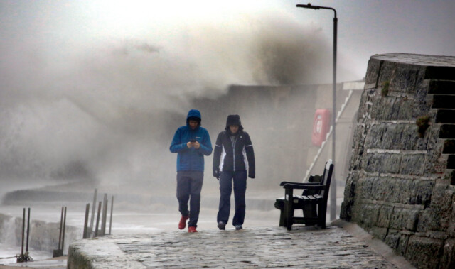
Waves hammed onto Brighton beach as the high winds and rain continue to batter the South Coast
Strong winds and wet weather have disrupted commutes
Blustery winds and heavy rain is expected to move across the South


Roads flooded in Sutton, Cambridgeshire due to the deluge


The deadly cyclone that has sent temperatures plunging across North America is also causing the UK to experience severe weather, the Met Office said.
Heavy rain is forecast to batter the North and Northwest throughout Thursday, with some snow falling on high ground.
Severe weather will also strike across the West, with blustery showers also forecast for the Southeast from Plymouth to Cardiff.
But drier conditions will be seen in Eastern regions including Norwich and York.
Southern regions including London and Brighton will remain mostly clear through the day with spots of showers, with temperatures remaining around 7C.
But temperatures will plummet into the evening, reaching 2C in Scotland as frost will set in.
Blustery winds and heavy rain is expected to move in from Northern Ireland towards Northern areas overnight.
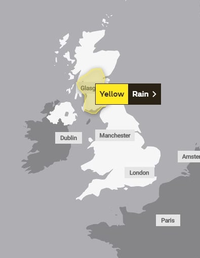
The weather front has led the Met Office to implement a yellow warning for severe rainfall across Southern Scotland through Friday.
The forecaster said heavy rain could bring some flooding and travel disruption.
And New Years celebrations over the weekend will be washed out, as heavy rainfall and high winds will hit across the nation through Saturday.
Wales and the Southeast of England will see the worst of the early morning storms, with Scotland and Northern Ireland also being hit.
The weather front will breeze Northwest through the morning, making its way up to Newcastle and Aberdeen.
Snow is also likely in Scotland over the weekend as the mercury will plummet, although the South is forecast to be much clearer.
But as bottles are popped and celebrations of the New Year begin at midnight on Saturday, the weather will clear up across some regions.
Festivities across central areas and the South Coast can expect mild conditions as the countdown begins – but Scotland, North Wales and Manchester will still see rainfall.
Meteorologist Simon Partridge said the wet and windy weather was being caused by the bomb cyclone in the US.
“The UK weather is going to remain unsettled with further spells of wet and windy weather due to the strengthening of the jet stream because of the weather in the US,” he said.
He said that the impact on the UK would be “nowhere near” as significant as it was on the US.
“The effect it’s having on the UK is nowhere near as dramatic because that system has brought up a lot of cold air further south, across the US,” he said.
He said the knock-on effect for the UK is spells of wet and windy weather over the next seven to 10 days.
“So the knock-on effect is that, like today, we had a spell of wet, windy weather – and there will be further spells of wet and windy weather,” he said.
LONG RANGE FORECAST
The clear overnight forecast won’t last for everyone though, as New Years Day will be marked by wet weather for Wales and parts of Scotland.
The Met Office’s long range forecast from January 2 to January 11 predicts more of the wintry weather of the last month.
The forecaster said: “Unsettled weather is likely to stay as we enter the new year, with rain for some, particularly in the far southeast and north initially.
“There is potential for some heavier bursts at times, particularly for western facing hills.
“Snow most likely restricted to higher ground in Scotland. Some drier and brighter spells remain possible, especially in eastern parts.
“Generally windy, with temperatures remaining near normal, perhaps slightly below average in the north.
“Further into the period, changeable conditions are expected to continue.
“With spells of strong winds for many, interspersed with colder more showery spells, some snow possible in the north, mainly over higher ground, but possible at lower levels.
“Temperatures likely staying mild in the south with a mixture of mild and colder spells in the north.”

Britain is bracing for a New Years Eve washout


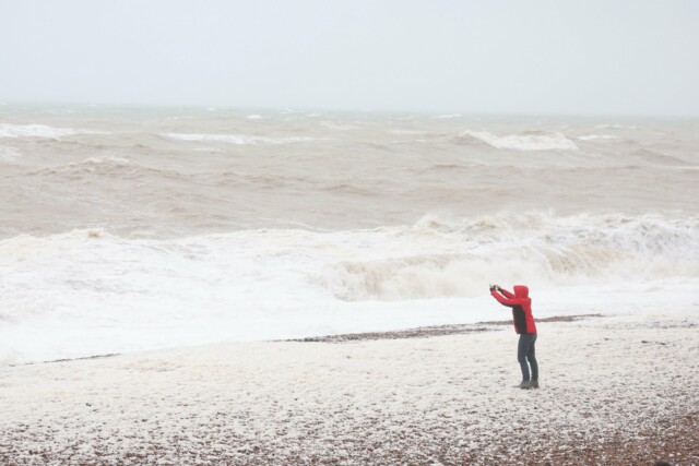
The weather bomb that has battered the US is set to hammer the UK

Brighton residents have been hammered by the wintry weather


